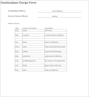
This design form illustrates the basic headings of the geodatabase. We can see the name of the database and the original feature dataset.
Some of the feature classes of the feature dataset have been listed to show the quantities of the data.
This next worksheet shows what some of the attribute tables of each feature class will contain. Keep in mind that an attribute holds a great deal more information, but this is a basic outline for reference. The null field determines whether a value can or cannot exist for a particular attribute. If null is checked to Y(yes) that means data is allowed to not exist in this category. The domain category states that an attribute may have a set of values allowed for that category. These are also known as domains.
The Domains worksheet shows what values each attribute can be labeled with. This helps in data consistency and allows new users to not get lost with your information. In order for an end-user to correctly query something a name or id must be spelled correctly. By using domains we tell the user and ArcGIS what something may be called therefore taking away the possibility of spelling errors.


No comments:
Post a Comment